

Last month, we discussed in a separate article all of the different sensors that UAV pilots should know about as more industries start to take advantage of drones for collecting a variety of data relevant to their industries. As that piece makes clear, there is an ever-growing number of options as drones become more accessible and sensors shrink to the point where they can be carried with a UAV without sacrificing power. Still, amid this growing space of sensors, lidar remains among the most crucial and powerful, and as accessibility for these systems improve it will be more important for pilots to familiarize themselves with this technology to open up more potential projects in the future.
Below, we hope to outline some of the most important points about these lidar sensors and the technology in general for UAV pilots who are looking to expand their toolkit and open up new potential job opportunities.
What is lidar?
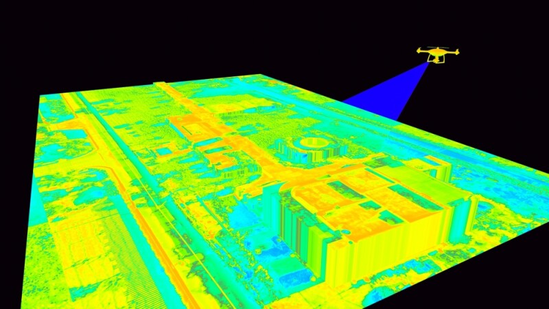
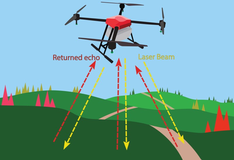
It makes sense to start at the most basic level with a quick introduction to what lidar actually is. There are more substantial resources with more technical details to be found elsewhere, but at the most basic level lidar provides a way to derive spatial context of a sign using many, many beams of light. These systems emit as many as hundreds of thousands of light pulses per seconds, with the light emitting until it hits an object, at which point it returns to the sensor. With millions of data points, the system can take the time it took for a point to return to the sensor and use that information to determine the distance of that object. From there, that information can then be turned into a point cloud, or a spatially accurate 3D representation of a given scene, be it a building, campus, landscape, bridge, or any other asset.
What is lidar used for?
There are a number of different use cases for lidar across many industries, from topographic mapping to capturing as-built progress on a construction site to creating a 3D model of a specific asset. As lidar systems for UAVs become more powerful pilots can expect job opportunities for all of the above and more, but today the main use cases are still around inspections of utilities, infrastructure, and other built structures. Powerline inspections, for example, often leverage lidar scans to derive an accurate assessment of current conditions, with artificial intelligence being applied to the resulting point clouds to quickly find anomalies and areas that could require maintenance and further inspection. Similarly, maintenance of large infrastructure like bridges and dams have turned more often to drone-based lidar with similar workflows, allowing for these inspections to be done much more safely than more traditional methods using tripod-based lidar systems.
Georeferencing is key
It’s one thing to be able to capture data using a lidar scanner with a drone, but oftentimes that data is limited in value – if not outright useless – if it’s not properly georeferenced. Fortunately for UAV pilots in particular, there are a few different ways to ensure their data is within proper geospatial context. For example, most commercial drones are typically equipped with GNSS receivers and IMUs, which combine to provide accurate location data for the UAVs – the exact accuracy depends on the GNSS receiver, but can be down to centimeter-level accuracy – while taking into account orientation and velocity. Moreover, the lidar sensors attached as payload can be synchronized with the GNSS receiver and IMU to ensure that each pulse can be attributed with an exact position and orientation.
To ensure even greater accuracy, pilots can also utilize ground control points, or GCPs. These markers can be placed throughout a specific scanning area, each with a known, precise geographic coordinate, and are picked up with the lidar scan. After the data collection is complete, pilots can align the data with these GCPs to correct any positioning errors that may have arisen internally and fine-tune the georeferencing process.
Post-Processing workflows
While there is always an outsized amount of focus on the process of collecting this lidar data, the truth is that the real value comes from what comes after the collection in the post-processing workflow. To put it simply, data is next to useless without the ability to analyze and derive insights from it, and that’s where the post-processing piece of the workflow comes in. There are a number of software solutions to deal with this post-processing work, and the increased investment around artificial intelligence is automating some of the tedious parts of this process.
That said, there are a few broad pieces to the post-processing workflow. First, it’s simply cleaning the data, which often contains noise from reflective surfaces or airborne particles. This can often be done with pre-set filters and aforementioned AI workflows. From there, it’s important to ensure the data is properly geo-referenced, as noted in the section above. Once all of this is set, the real analysis can be done, including classifying point clouds – i.e. categorizing important pieces of a dataset, such as vegetation, buildings, signs, etc. – fusing the data with other data, such as photogrammetry to create colorized point clouds or lidar data from terrestrial systems, and visualizing and sharing the data.
Again, much of this work can be done at least with heavy assistance from AI, but a pilot can separate themselves from competition by showing competence in not just collecting the data but processing and analyzing it.
Other factors to consider
These are the main points that drone pilots should consider when diving into lidar usage, but there are other factors that are important to bear in mind amid the technical knowledge. For one thing, while it may seem obvious it’s important to consider the effects of the sensor on the actual capabilities of the drone. For example, while these sensors are significantly lighter than even a few years ago, they will reduce the flight time and altitude of your UAV. This will vary by sensor and system – and indirectly correlated to the power of the sensor – but it’s important to inquire about both weight and battery requirements when purchasing a scanner.
As lidar becomes more mainstream and more industries become aware of its value, drone pilots can be expected to be asked about the technology in meetings. In such a competitive space, it’s imperative to have access to as many tools as possible, and keep as many potential customers in one’s orbit as one can. Keeping up to date with sensors like lidar, and knowing how to utilize the technology, is a crucial way to do just that.

.jpg.small.400x400.jpg)


Comments