

With each passing year, there are more and more industries taking advantage of UAV technology to streamline workflows and open up new potential offerings for their customers. Even though it’s still a relatively new sector, the drone industry is rapidly expanding in adopters for a number of different reasons. For one thing, hobby drones are becoming more accessible, making it easier for people to imagine how the technology can be used in their businesses. Regulations are also starting to clear up and allow for more innovation. The hardware is also becoming easier to use and move around to different sites, making drones much more practical than even five years ago.
Perhaps even more important than all of these advancements has been the improvements in payload sensors. Drones alone, of course, are not going to provide value for most use cases; it’s the payloads that are able to be attached and collect crucial data that lead to the ROI for all of these industries. Today, many data collecting sensors have been improved to the point where their size can be significantly reduced without sacrificing power. As a result, these sensors can now easily be carried by drones for long enough flight times to complete crucial missions, and in some cases UAVs can carry multiple sensors to produce an even more complete dataset.
Today, there are so many options for sensors that it can be overwhelming for newcomers to the industry to know what they should be utilizing for their work. Below, you can find a quick outline of the most popular sensors featured on drones today.
Internal Sensors
Generally speaking, when we talk about sensors being used today in the commercial UAV industry, we’re talking about sensors used as payloads to collect data. That is what the bulk of this article will focus on, but it makes sense to also briefly touch on these internal sensors.
Especially as autonomous (or semi-autonomous, or remote-controlled) drones become more common across many different industries, it’s important to know how these internal navigation systems work. That largely relies on a series of internal sensors. This includes IMUs, or inertial measurement unit, which can internally track a drone’s orientation, acceleration, and velocity to ensure stable flight and precise navigation.
There are also more specific sensors, like an accelerometer, which internally measures a UAV’s acceleration in three dimensions; a gyroscope, which measures a drone’s rotational movement across three dimensions and detects changes in orientation; and a tiltmeter, which measures the angle of tilt for a drone relative to the Earth’s gravity.
All of these sensors are crucial to a successful mission, and it’s important to understand these components for the best results in a project.
Data-Collecting Sensors
As noted above, though, it’s these external sensors that serve as payloads and collect various types of data that really provide maximum value for drone pilots. Below, you can find a list of the most common payload sensors and what kind of data they provide. Every job requires different data types, so knowing what is most valuable for a specific job is crucial for efficient and valuable work.
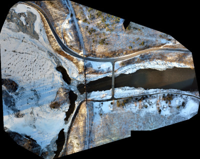
- RGB Camera - This is the most common type of sensor for a drone, but that doesn’t mean it’s not valuable. An RGB camera is just what you think of as a normal camera, capturing images in red, green, and blue channels to produce color photographs. Today, these cameras can produce images in extremely high-resolution, opening up usage in almost every drone-using industry. These cameras are also used for photogrammetry techniques, which take a series of photographs to create a 3D model. That includes everything from nature photography to infrastructure inspection to public safety, and much more.
- Video Camera - Here we have another sensor that is largely self-explanatory but still very valuable. Being able to collect video adds even more context to products than static images, and like RGB cameras they are available in high-resolution. More recently, with the advent of better connectivity thanks to innovations like 5G service, it’s more plausible than ever to collect live-streamed video from drones, adding even more to industries like public safety and inspections.
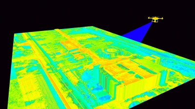
- Lidar - As we start to get into the more technical payloads, lidar is among the most common for industries like surveying and mapping as well as infrastructure inspection. Lidar works the same way that sonar works for animals like bats, but instead of sending out sound waves these sensors work by utilizing light beams. Sending out tens of thousands (and often more) beams per second, these sensors measure how long it takes for the light to bounce off an object and come back to the sensor. Once that data is processed, users can create a 3D point cloud in proper spatial context. More often than ever, these sensors are being combined with RGB cameras to combine the visuals from the latter with the geo-referencing from the former.
- Radar - Radar is very similar to lidar – and likely more familiar to non-experts – but not used quite as well. That said, public safety and agriculture end users do utilize radar at times, which uses radio waves instead of light beams. There are pros and cons to each, with radar working better for longer-range detection.
- Magnetometer - The magnetometer could theoretically fit into the previous section regarding internal sensors as these can be used to aid navigation and stability for a UAV. However, they are also used to collect crucial data by geoscientists and other users. These are certainly more specialized sensors, but with a magnetometer an end user is able to measure anomalies and other information regarding the strength and direction of the Earth’s magnetic field. Among other uses, this helps detect underground assets that may not have been properly mapped.
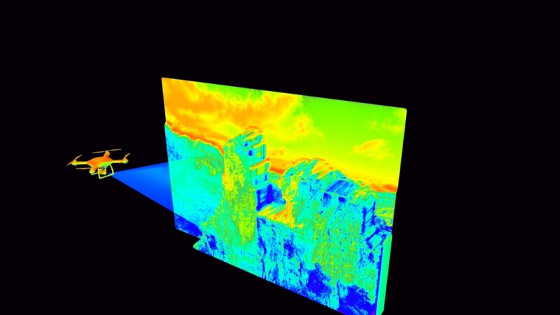
- Thermal Sensor - A thermal sensor is similar to a camera, but instead of capturing a scene on the color scale it detects infrared radiation emitted by objects and translates it into thermal images, or even video. These sensors are particularly useful in areas where visibility is low, such as monitoring wildlife in a forest or working in a public safety context at night. These sensors can also detect temperature differences, something that can be very valuable in inspection workflows when trying to find portions of an asset that may be over (or under) heating.
- Hyperspectral Sensor - Finally, we end with one of the most complex and valuable sensor payloads available for drones today with the hyperspectral sensor. We’ve discussed some sensors above that collect data on specific spectrums, be it infrared or RGB, but the hyperspectral can analyze light across a wide range of wavelengths. This allows for precise identification and differentiation of an asset or landscape and is used across many industries, including environmental monitoring, agriculture, mining, and more.
Making the Most of these Sensors
These are the most common sensors found on UAVs today, but there are more specialized sensors being developed all of the time. As a drone operator, it’s crucial to find the sensors that make the most sense for your specific use case, avoiding having to learn many different systems that don’t apply. Being able to properly and safely fly UAVs for different end users is crucial, but by being able to identify and utilize the variety of sensors available on the market today – and keeping up with the constant shifts in this market – can take a drone pilot’s operations to the next level.


Comments