

Traditional tunnel inspections have proven to be costly, inefficient, and dangerous. A typical tunnel inspection can take days, and involve road closures, setting up scaffolding and ropes to access areas of concern, and putting lives at risk. Using drones, teams can gather accurate information about ground conditions and various geological features that may indicate where walls are likely to fall in locations all over the world.
In Norway, tunnels require inspections every five years. During a routine inspection of the concrete lining of the Strindheim tunnel, cracks were discovered that required further assessment. The National Road Authority of Norway (SVV) saw an opportunity to test a safer inspection method that also added 3D mapping to assess damage and plan repairs.
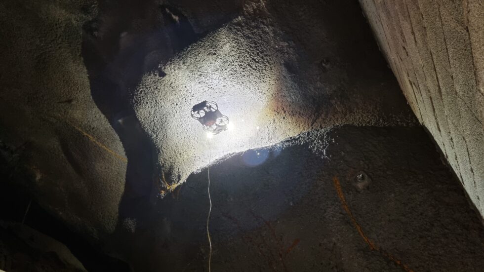
They reached out to Norwegian company, ScoutDI, to test their Scout 137 drone solution for a routine inspection on the tunnel. Scout 137 was an obvious choice to carry out this test as it’s fully equipped to deal with all the challenges involved in inspecting an enclosed area such as tight and high spaces, darkness, and absence of GPS signal.
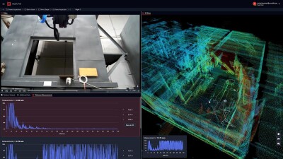
“The Scout 137 is a complete inspection solution that seamlessly integrates into existing maintenance workflows through its use of standard data formats, structured reporting, and intuitive data accessibility,” said Eivind Sivertsen, Marketing Director at ScoutDI. “The data it collects is structured, accessible and visualized in our cloud service, the Scout Portal, that can also integrate with asset management systems via its API. It also features inspection streaming and an interactive 3D point cloud.”
This kind of complete drone solution for tunnel inspections can dramatically improve the efficiency, safety, and accuracy of tunnel inspections compared to traditional methods. Common defects found in tunnels include cracks in sprayed concrete, water ingress, and structural deformation. Where a traditional tunnel inspection can take days, drone inspections are done in a matter of hours and produce highly detailed results that can be in the customers’ hands the same day.
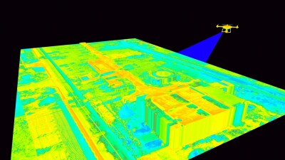
Additionally, drones can fly up close to defects to get detailed images, which are usually in very dangerous areas for humans to inspect up close. When using lidar, they can scan the entire tunnel lining in 3D to detect structural changes or defects without intrusive methods. Unlike most drones that depend on GPS, the Scout 137 system uniquely utilizes SLAM-based navigation using lidar, enabling it to operate effectively in dimly lit or confined tunnel spaces where GPS is unreliable.
“Being deprived of light, camera-based navigation is not ideal,” Sivertsen told Commercial UAV News. “Those sensors will have no references for positioning, making the drone drift off and crash into things constantly.”
That’s part of the reason that accuracy and reliability considerations are such a priority when choosing a drone solution. For SVV, having a drone powered by a cable instead of a limited-life battery made Scout 137 the ideal choice. While most Lidar-equipped drones operate on batteries that rarely last longer than 10 minutes, the tethered Scout 137 defies this issue by being directly connected to a power source, allowing the job to be done without the need to charge or swap a battery.
These applications showcase how this kind of complete drone solution has the potential to be adopted in other ventures for infrastructure maintenance such as routine monitoring on a smaller scale for damage prevention. It can also be used on other assets that are in GPS-denied areas like bridges or underground facilities. However, successfully implementing a drone solution for infrastructure inspections requires meticulous planning. Several key questions need to be considered before moving forward with drone adoption.
“First, it’s important to clearly define inspection goals and data requirements,” he said. “What kind of data do you need, and what kind of payload does that require?” It’s also essential to ensure that flight operations are conducted safely and in accordance with relevant aviation regulations. Depending on your location, this could involve specific pilot licensing, operator certifications, or other permissions—so it's wise to research these requirements early. Selecting a drone with suitable positioning systems for GPS-denied environments will help avoid setbacks in terms of navigation and stability. Finally, consider your anticipated flight times and make sure you’re equipped with the necessary tethering system and power source.”
To learn more about the Scout 137 complete drone solutions and see examples of data capture, visit their website.


Comments