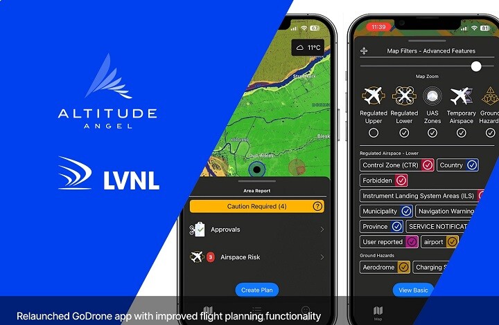
Netherlands ANSP LVNL and Altitude Angel, the world’s most trusted UTM (Unified Traffic Management) technology provider,  have announced the new look GoDrone flight planning app will be going live.
Designed and powered by Altitude Angel, GoDrone has established itself as the flight planning app for professional and recreational drone pilots across the Netherlands since its launch in 2020. GoDrone 2.0 will bring with it a host of new features giving users an even greater understanding of the Netherlands’ airspace and how to access it safely and securely.
Available on iOS and Android, the extensive update encompasses a suite of updated features and includes enhanced integrated flight planning, advanced flight plan drawing tools, and in a first for the Netherlands - Flight Approval services – the ability to request access to fly digitally in airspace such as an airport CTR– through the app.
As part of the Flight Approval Service are new and innovative features. An important change in the approval process for flying within the CTR for drones is the introduction of an additional status for mission plans. The status ‘reviewed’ is granted when a mission plan has been reviewed and provisionally accepted by LVNL’s Operational Helpdesk. On the day of the flight, if air traffic control signs off on the flight, the mission plan is given the status ’approved’ giving the drone pilot permission to call up to the tower directly.
‘’Providing accurate information aimed at the drone community is essential to ensure safe aviation in controlled airspace. Using user panels, we collected information and feedback from drone community to optimize the information provision’’ says Maartje van der Helm, LVNL, General Manager Performance and Development. ‘’With the further development of GoDrone, we are taking steps towards safer flight movements of unmanned and manned traffic in controlled Dutch airspace.’’
Paul deHaan, Altitude Angel (Netherlands), Managing Director, added: “The updated GoDrone app was designed with two things in mind: user experience and safer skies. The engineering team at Altitude Angel re-designed the app after collating, analysing and understand user feedback. These improvements will further enable the growth and commercial opportunities for unmanned aviation in the Netherlands.”
About Altitude Angel
Altitude Angel is an award-winning provider of UTM (Unified Traffic Management) software, enabling those planning to operate, or develop UTM/U-Space solutions, to quickly integrate robust data and services with minimum effort.
Altitude Angel’s market-defining technology is providing a critical, enabling service on which the future of UTM will be built across the globe. Altitude Angel is leading a consortium of businesses to build and develop 165 miles (265km) of ‘drone superhighways’ connecting airspace above Reading, Oxford, Milton Keynes, Cambridge, Coventry, and Rugby over the next two years. The Skyway superhighway network, enabled using Altitude Angel’s patented ARROW technology, will unlock the huge potential offered by unmanned aerial vehicles and be a catalyst to enable growth in the urban air mobility industry.
Altitude Angel’s first party solutions also power some of the world’s leading ANSPs, aviation authorities and Enterprises, including LVNL (Netherlands) and Avinor (Norway), empowering them with new capabilities to safely manage and integrate drone traffic into national operations.
By unlocking the potential of drones and helping national aviation authorities, ANSPs, developers and enterprise organisations, Altitude Angel is establishing new services to support the growth in the drone industry.
Altitude Angel was founded by Richard Parker in 2014 and is headquartered in Reading, UK.
Altitude Angel’s developer platform is open and available to all at https://developers.altitudeangel.com.
Source: Press Release


Comments