

As we continuously push the limits of aerial insights capture and processing, we’re excited to launch MAP61, our most efficient mapping sensor to date.  This cutting-edge payload sets a new standard for efficiency, helping professionals generate larger mapping outputs in less time. With its unique ultra high-res sensor configuration, it also captures detailed 3D data in a single pass, delivering impressive results and analytics for vertical assets.
MAP61 can cover up to 460 hectares (1,140 acres) in a single flight, making it a productivity boosting tool for anyone serious about large-scale aerial mapping and 3D reconstruction.
“Imagine cutting your fieldwork time from an hour to just 35 minutes, while also doubling your processing speed,” said Julian Surber, Product Manager at Wingtra. “With MAP61, customers save time in both capturing and processing, whether their projects call for 2D or 3D optimized data. This isn’t just a time-saver—it’s a boon for productivity and improving the bottom line.”
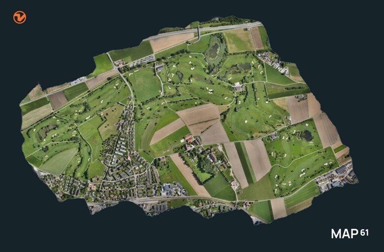
This golf course map, used for management tasks like rating, planning, design, and maintenance organization, was captured in just 37 minutes with the MAP61 sensor, covering 270 ha (670 ac) at 120m (400 ft).
How does MAP61 achieve this?
By requiring fewer images to cover large areas, MAP61 speeds up data processing, slashing the time from fieldwork to final deliverables. This means projects can be completed in a single day instead of two—this swift turnaround is crucial in industries like construction, where MAP61’s oblique sensor configuration makes it possible to map long highway corridors without interrupting traffic.
Via a unique tilted configuration, MAP61’s 3D reconstruction capabilities make it perfect for applications like land management, urban planning, highway mapping, and tracking progress in open-pit mines. In fact, the sensor cuts field time for vertical resolution and accuracy in half, eliminating the need for cross-hatch data capture. Single passes deliver rich, detailed 3D outputs.
The tilted angle and wide field of view of MAP61 enable efficient and high accuracy data capture even when flying parallel to infrastructure such as highways, a real time and money-saver since traffic can continue to flow.
Step into the future of mapping
“Our customers often work in challenging environments like open pit mines, highways, or urban areas, where time is tight and flight windows are limited,” added Surber. “In these cases, quickly covering large areas is critical to reducing costs, ensuring safety, and delivering timely data to stakeholders. MAP61 shines in these situations, offering speed and efficiency without sacrificing image quality.”
What truly sets MAP61 apart is not only its versatility, but its seamless integration into an intuitive mapping workflow. Only Wingtra combines high-efficiency mapping with vertical take-off and landing (VTOL) and WingtraCLOUD, creating an all-in-one solution.
In fact, you can plan, capture, and process everything without switching software—this all-in-one workflow inherently minimizes errors. Aerial insights are now accessible to everyone, regardless of technical skill. Scaling up and producing and using detailed orthomosaics and point clouds daily, is easier than ever.
Source: Wingtra


Comments