

The all-in-one geospatial software, Global Mapper Pro®, really does it all! From raster data viewing and editing to vector feature creation, Global Mapper Pro goes further to include tools for point cloud analysis and classification. The Pixels to Points® tool in Global Mapper Pro even enables users to create 3D data from overlapping drone/UAV-collected images.
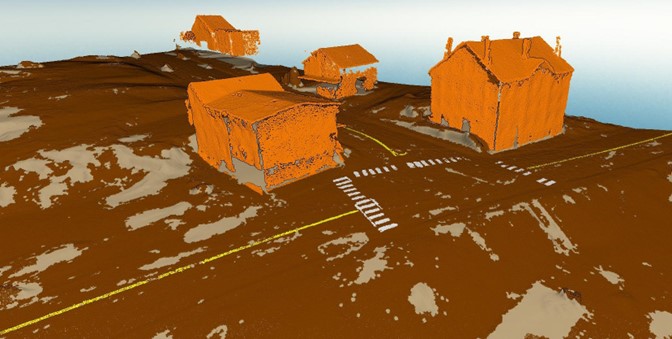
The Pixels to Points tool uses an overlapping, geotagged image set as an input to generate a seamless orthoimage, point cloud, and textured 3D mesh. These outputs are created using structure from motion analysis, a process which creates very high-resolution data outputs. The use of surveyed ground control points in the Pixels to Points tool will help enhance the positional accuracy of the created data layers.
In Global Mapper Pro version 26.0, ground control points can be automatically identified, improving on the previous workflow that included the tedious task of individually tagging each control point in each image. 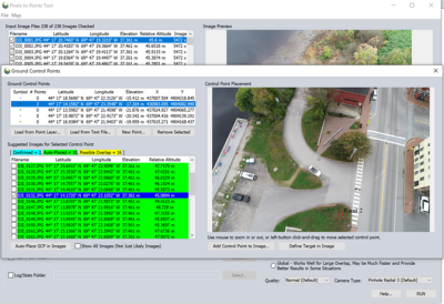 Automatic ground control point placement uses the control point location and calculated image coverage polygon for each image to identify candidate images where a ground control point may appear. The user then identifies the control point target. This might be a manually placed target board, or a fixed and identifiable feature on the ground, such as a manhole cover. The user then asks the Pixels to Points tool to place the control point in all images where the target is found. The user can then adjust and confirm the control point placements as needed before running Pixels to Points to generate the high-resolution data outputs.
Global Mapper 26.0 also boasts a significant reduction in processing time in the Pixels to Points tool. Improvements and optimizations to the underlying processes in the Pixels to Points data creation process produced up to 50% improvements in processing time. Generating high-quality 3D datasets from drone/UAV-collected images makes Global Mapper Pro an even more valuable tool across many industries.
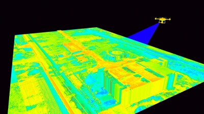
Once a point cloud has been generated with the Pixels to Points tool, data analysis can continue in Global Mapper Pro with the many point cloud analysis tools including decimation, classification, and creation of derivative data layers. Global Mapper Pro is a versatile asset for data analysis, enabling users to perform entire workflows within the software.
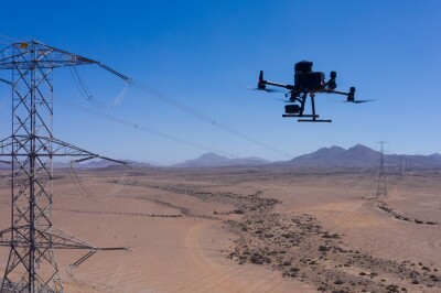
Global Mapper Pro’s Automatic Point Cloud Analysis tool has options for the classification of standard classes including noise, ground, buildings, vegetation, powerlines, and poles. This tool additionally offers custom-trained classes using advanced segmentation and machine learning methods. Additionally, the Automatic Point Cloud Analysis tool has options to identify model key points and extract vector features from the classified point cloud.
Global Mapper Pro enables users to custom-train point cloud classes for classification. The software compares a user's defined class signatures to a dataset using machine learning-powered classification methods. Initially, running a geometric segmentation analysis, a process that does not classify but identifies clusters of congruent points based on user specified attributes, helps in the collection of the training data used to create the class signatures. The geometric segmentation tool in Global Mapper Pro allows the user to specify which point cloud attributes to use and how heavily to consider them in the analysis. A photogrammetric point cloud, such as one generated with Pixels to Points, does not have the same attributes as actively collected lidar, but the segmentation analysis can still be used. In this case color, curvature, and intensity – a grayscale color value, not true intensity – are used to identify road lines in the downtown area of this point cloud. In this sample dataset, the yellow road, centerlines, and crosswalk hashes identified in a small portion of the point cloud can be used to train custom classifications.
Identification of these custom classes, both subsets of ground classified points, can then be conducted in the Automatic Point Cloud analysis tool. The signature definitions for the created custom classes can be saved from Global Mapper Pro to be used on similar projects and/or shared with colleagues.
The workflow in Global Mapper Pro does not need to end with a classified point cloud. While the data can be exported to one of many supported point cloud formats, including LAS/LAZ, a terrain model can be generated, contours created, breaklines extracted, and much more. Features can also be extracted from the classified point cloud through the Automatic Point Cloud Analysis tool, or by generating bounding areas that help to smooth out the extracted areas. In this dataset the custom road centerline and crosswalk classified points can be extracted and converted to line features accurately representing the markings on the road.
Check out bluemarblegeo.com/global-mapper-pro for more information on completing entire workflows in Global Mapper Pro with Pixels to Points and the cutting-edge point cloud analysis and classification tools. Download Global Mapper Pro version 26.0 to try out Pixels to Points and the many other tools, including a new deep learning-based image analysis toolset in the new Global Mapper Insight and Learning EngineTM.


Comments