

Ever since the introduction of uncrewed aviation platforms (drones) for cartographic purposes over a decade ago, we have seen a proliferation of use cases in which photogrammetry and land surveying companies alike have adopted the new technology, but, for regulatory reasons, only for small areas and relatively easy projects.
The reason is simple. In the summer of 2016, the Federal Aviation Administration (FAA) issued its Part 107 regulation in which drones were finally allowed to use the National Airspace (NAS) under very strict conditions such as flight altitude and, most important for the mapping industry, distance to the operator.
This key restriction to maintain the aircraft within the visual range of the operator meant that uncrewed aircraft had to fly only a few hundred yards away from the pilot in command (PIC) to be a legal mission. This is a major obstacle to photogrammetric flights which normally cover hundred if not thousands of square miles on each mission to minimize costs and take advantage of clear and cloudless days. When the operator is using a small multi-copter, this visual restriction seems to be less of a problem, because of the short battery life of most of these commercial platforms. With existing fixed wing platforms, especially those with hybrid powerplants, Beyond Visual Line of Sight (BVLOS) limitation imposes a costly external restraint.
The publication of a Notice of Proposed Rulemaking (NPRM) by the FAA for Part 108 is imminent, and we expect a full regulation within two years.
But what is Part 108 and why is it so relevant to our industry? Part 108 is an improvement over Part 107 in many ways, but especially by allowing longer flights. In other words, uncrewed aircraft will be able to fly away from the pilot in command as far away as they can as long as communications are maintained 100% of the time and with 100% reliability and redundancy. And this is perhaps why the FAA is taking their sweet time enacting this regulation. Guaranteeing 100% reliability and redundancy is not an easy task, but ingenious solutions are being proposed as we speak to prove to the federal agency that drones are ready to safely join their counterparts in the National Airspace System (NAS).
While we wait for the FAA, the National Aeronautics and Space Administration (NASA), industry, and academia to solve the many technical questions involved in a full integration, let us focus on the mapping industry and how this upcoming legislation will affect it.
So, in 24 months or so, photogrammetry companies will be able to use fixed-wing drones at higher altitudes and for longer periods of time. As we all know too well, these two characteristics, altitude and time in photogrammetry only mean one thing: more area!
It would be useful to analyze which of the existing non-piloted aerial platforms would offer the best options and would benefit the most from the new regulation:
- AgEagle eBee – aBee X - https://ageagle.com/drones/ebee-x/
- 90 minutes flight time. Can map 1,235 acres at 400 ft altitude with a 3.6 lbs of useful load.
- 90 minutes flight time. Can map 1,235 acres at 400 ft altitude with a 3.6 lbs of useful load.
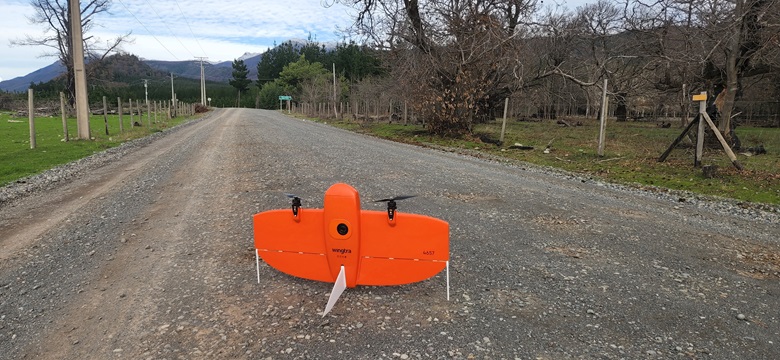
- Wingtra – Wingtra One Gen II - https://wingtra.com/mapping-drone-wingtraone/
- 59 minutes flight time. Can map 1,140 acres at 400 ft altitude with a 1.8 lbs of useful load.
- 59 minutes flight time. Can map 1,140 acres at 400 ft altitude with a 1.8 lbs of useful load.
- Quantum Systems – Trinity Pro - https://quantum-systems.com/trinity-pro/
- 90 minutes flight time. Can map 1,729 acres at 400 ft altitude with a 2.68 lbs of useful load.
- 90 minutes flight time. Can map 1,729 acres at 400 ft altitude with a 2.68 lbs of useful load.
- Delair – UX11 - https://delair.aero/delair-commercial-drones-2/professional-mapping-drone-delair-ux11-2/
- 80 minutes flight time. Can map 300 acres at 400 ft altitude with a 1.5 lbs of useful load.
- 80 minutes flight time. Can map 300 acres at 400 ft altitude with a 1.5 lbs of useful load.
Now that we have established that we can cover more area with a fixed wing drone, let us analyze a case study that will take full advantage of more altitude and no visual restrictions to the operator.
Public Utility Corridor
This project was executed under a special waiver or Certificate of Authorization (COA) which authorized the lines to be flown away from the visual range of the operator. It is important to note that after Part 108 is enacted, these exact missions will be possible without special permission. The requirements for the project were as follows:
- Length of corridor: 12.42 miles
- Width of Corridor: 1,500 ft
- 80% longitudinal overlap
- 70% lateral overlap
- GSD: 1.2 inches
The flight was executed using a Wingtra drone with a 42 MP camera and a 35 mm fix lens. The specifications for the flight to comply with the project requirements were as follows:
- Altitude of Flight: 820 ft
- Speed of Flight: 31 knots (36 miles per hour)
- Four useful flight lines.
- Total flight time 6.1 hours
This is the typical project that would take days to accomplish with a regular multicopter in Part 107 world because of the infamous combination of altitude restrictions and flying time.
Even though we realize that Part 108 is still at least 18 to 24 months away, it would be useful to start exploring non-piloted aerial platforms that can offer the best performance in a regulatory environment in which we can fly our aircraft for more than one hour and cover hundreds if not thousands of acres a day, depending on the accuracy of the project.
We are still years away from a world in which crewed and non-crewed aircraft will share the NAS freely and without restrictions, but this time will come, and we will see a full integration of both platforms surely within the next decade. At that point, fixed wing drones will be able to more closely compete with traditional piloted platforms, but as we prepare for that futuristic prospect, it is good to think that aerial mapping and photogrammetry are becoming more and more accessible to land surveyors the world over.


Comments