Being used in more than 126 countries by drone mapping companies, GIS experts and enterprises, Indshine allows professionals to get the most out of drone maps. From India to the world, Indshine is a completely device agnostic, browser-based platform for drone maps.
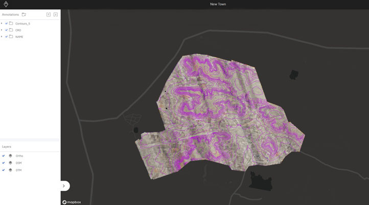
Designed for Infrastructure, Mining, Forestry, Agriculture, Construction and more, Indshine makes drone maps’ visualization and analytics “more flexible, collaborative, and powerful.” Users can add multiple layers of orthomosaics, elevations models, thermal & NDVI maps in a single project, and calculate stockpile volume, cross section profile or measure distances and area. With no hardware limitations, your data is always available from any device.
Last month, the company launched Team Plan, “an important step towards the goal of making the usage of drones easy and accessible”, said Himanshu Nagrath, CEO at Indshine. It allows users to create 200Gb storage workspaces, making it easier to share projects within a company and with clients. It also enables unified billing and invoices for the companies and each workspace member has access to 10GB of personal storage for four personal projects.
Since late 2019, Indshine has been used by companies all around the world in various ways. Here are a few examples:
- In India, the Narmada Darshan Path project took advantage of the software for post-analysis of drone maps and helped Jabalpur City officials finalize and review the road alignment.
- To build railway bypasses at six major railway junctions, Indian Railways used Indshine to plan the best possible alignments and make improved day-to-day decisions.
- Servicios de Ingeniería, a Mexico-based service provider to the Construction, Mining, and Oil & Gas industries, used the platform to assure there were no gaps in the design during the construction of a gas station, which saved 6 months from the scheduled timeline.
- After hurricane Dorian, Century Roofing Specialists, a commercial and industrial roofing company in Florida, US, used Indshine to create detailed insurance assessment reports, ensuring 80% of insurance paybacks went to household owners.
- In São Paulo, Brazil, Indshine helped Velbrax Agro, a company working in the precision Agri-Tech market, to detect and quantify plant failure in sugar cane fields, saving half a million dollars in 250 hectares.
To understand what Indshine does and the type of data it provides, the company created a project library featuring sample datasets shared by organizations. In addition, for anyone interested in getting into drone mapping and surveying, Saksham Bhutani, Marketing Head at Indshine, wrote a blog post about what aerial mapping is, what we get out of aerial mapping, and its applications. For drone businesses who want to grow, Indshine Product Evangelist Shashank Tewari’s blog post talks about how digital marketing can help.
Apart from the paid subscription plans starting at $12 per month, Indshine recently decided to offer a free limited starter plan with 5GB of storage with no time limit to everyone due to how the COVID-19 pandemic is forcing millions of people to work from home.


Comments