


SPH Engineering, the leading UAV software solutions, and integration services provider, has launched UgCS Open today, a free version of its industry-leading software.  It provides the same 3D flight planning, terrain-aware automation, and mission control capabilities as the paid version, with just a few limitations. The new product is making advanced drone flight planning more accessible.
Bringing Professional Tools to More Pilots
For over a decade, UgCS has been the choice of drone professionals handling LiDAR surveying, mapping, photogrammetry, and many other tasks. With UgCS Open, more drone pilots can use all UgCS features without additional charges and time limits. “We’ve spent years pushing the boundaries of drone mapping and surveying,” says Kristaps Brass, UgCS Product Owner. “But we also recognize that getting started with a professional drone must be made easier and more accessible. UgCS Open removes the biggest barriers to professional drone planning and gives everyone access to precise and reliable tools without a time-limited trial or any upfront costs.”
A Free Entry Point to Drone Mapping
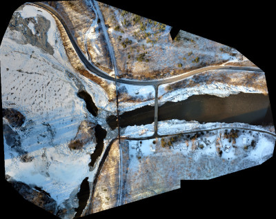
UgCS Open offers the same 3D flight planning, terrain-aware automation, and mission control as the paid version of UgCS Expert. The difference is that UgCS has just a few limitations — two routes per day with a maximum distance of 250 meters per route without connection to DJI Cloud.
UgCS remains dedicated to professionals planning complex missions; however, UgCS Open makes starting easier, especially regarding LiDAR flights, UAV photogrammetry, automated inspections, and terrain-aware flight planning.
UgCS Open is available for free download here
UgCS SPH Engineering is one of the world’s leading flight-planning software solutions for drones, trusted by professionals in over 150 countries. UgCS supports popular drone platforms, such as DJI M350, M300, Mavic 3 Enterprise, Matrice 4 Series, M600, and many others. Unlike cloud-based solutions, UgCS runs locally on PC/Mac, offering full offline capabilities and a fast, 3D flight planning environment. UgCS enables complex missions such as LiDAR, photogrammetry, corridor mapping, and more.
About SPH Engineering: SPH Engineering is a leader in drone technology development, providing UAV software solutions, integration services, and custom development to advance drone applications for surveying, data collection and processing, and entertainment. Founded in 2013 in Latvia (EU), SPH Engineering has a global customer and partner network in over 150 countries. Core technologies developed by SPH Engineering:
- UgCS: Flight Planning & Control – One of the world's leading flight-planning software solutions for complex drone surveys.
- Integrated Systems – The core technology SkyHub enables the advanced integration of drones, diverse sensors, and UgCS software, expanding capabilities in geophysical, hydrographic, industrial, archaeological surveying, and environmental monitoring.
- Data Processing & Custom Development – Solutions for image, point cloud, and geophysical data processing to facilitate drone-based businesses.
- Drone Show Technologies – All-in-one solution to manage drone light shows for entertainment and advertising.
Source: Press Release

.jpg.small.400x400.jpg)


Comments