

Over the years, Commercial UAV News has highlighted the power of uncrewed systems to help emergency responders and government officials before, during, and after natural disasters.
For example, in January 2023, we published a piece highlighting the ways Frontier Precision Unmanned helped collect crucial data following 2022’s Hurricane Ian. In the wake of the storm, the NHERI Natural Hazard and Disaster Reconnaissance (RAPID) Facility turned to surveying and mapping experts Frontier Precision Unmanned. Flying over some of the most severely damaged communities, Frontier Precision was able to collect accurate, detailed data that was used to create high-resolution 3D models to help researchers develop solutions for more resilient communities.
Similarly, in June of this year, we reported on an agreement between the National Oceanic and Atmospheric Administration (NOAA) and Verizon Frontline to work together on disaster-related projects. Through this three-year Cooperative Research and Development Agreement, NOAA will identify storm-damaged areas that need assessment, and the Verizon Frontline Crisis Response Team will provide uncrewed aircraft systems, sensors, and personnel to collect aerial imagery.
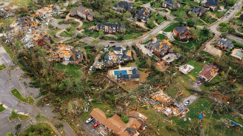
This fall’s two deadly hurricanes in the Southeastern US, Helene and Milton, once again demonstrated the important—and the power—of uncrewed technology in performing crucial public safety and research tasks.
Even before Helene or Milton made landfall, NOAA was flying drones into the storms to collect information on temperature, wind speed, and pressure. According to an article in Popular Science, NOAA used Altius-600 and Blackswift S0 vehicles to capture “crucial data to help NOAA chart out a storm’s course trajectory and severity.”
According to a Mashable report, NOAA’s efforts also included a collaboration with Saildrone to “gather novel data about these cyclones, and how they evolve.” The article stated that Saildrone’s vehicles were used to capture “footage in the storm's eyewall, home to some of its strongest winds.” NOAA has turned to Saildrone’s vehicles in disaster situations because they have “proven excellent at directly gathering observations of ocean and atmospheric conditions on the sea surface. It's there, where the oceans interact with the air, that hurricanes start to strengthen, sometimes rapidly.”
Once these storms hit the mainland, the Popular Science article reported that local officials and first responders deployed drones to “aid in search and rescue missions and overall damage assessment.” Many of these UAVs carried thermal imaging camera payloads to “help rescue teams spot heart signatures of missing people who may otherwise be obstructed by debris.” In addition, high-resolution cameras attached to drones were flown to capture photos and video “of broken bridges, downed power lines, and other crumbling infrastructure” and to “help officials prioritize aid efforts and bring much-needed electricity and communications equipment back online.”
In addition to the work of local officials and federal agencies like NOAA, private citizens also used their drone expertise to aid in relief and recovery efforts. For example, Dronelife reported on “a small group of private drone operators stepped in to deliver life-saving supplies” those who were left isolated by the storms. This team, led by Jeff Clack, chief supervisor of operations for Bestway Ag, “flew heavy-lift drones to deliver food, medicine, baby formula and other much-needed supplies to about 100 people who were cut off from other help in the mountainous region” of western North Carolina.
Similarly, the Popular Science piece described the work of local farmers in North Carolina who “combined simple hobbyist drones and cut-down shopping carts to create impromptu DIY disaster response vehicles.” In fact, one of the farmers “reportedly attached a 40-foot rope to a drone normally used to spray crop fields and instead used it to air-drop critical supplies in difficult-to-reach areas.”
Private drone companies also contributed to disaster relief efforts. sUAS News reported that drone technology company Red Cat Holdings, Inc. received “an order by the Florida Army National Guard for its Teal 2 drones.” These UAVs, the article stated, “will be used to support the ongoing disaster response to Hurricane Milton, which has left more than 3 million people without power.”
Also, following Hurricane Helene, Censys Technologies Sentaero 5 Unmanned Aerial Systems crews were “dispatched to collect crucial data across some of the hardest-hit areas, focusing on key infrastructure like roads.” According to a Dronelife story, these vehicles helped teams gather “extensive information on road blockages, asset damage, and debris accumulation, which would become essential in the ongoing recovery efforts.”
Moreover, TechCrunch described the work of public safety drone startup Paladin in storm-damaged Asheville, North Carolina. In the aftermath of Hurricane Helene, Paladin’s “30-member team jumped into action working nights and through the weekend to assist Asheville’s police department with locating people and dropping off supplies.” Despite the city’s Asheville’s “closed roads and lack of cell phone or internet service on the ground,” Paladin was able to assist local officials “because its software could control drones remotely from the company’s Houston headquarters.


Comments