

While advocates across the drone industry have long sought to enable scaled commercial operations, the number of aircraft involved at this level represents a major technical challenge. What does it mean to ensure drones can safely interact with each other? How will this info be shared with airport operations on the ground? A new platform from INVOLI that serves as the world’s first-ever low altitude surveillance supplemental data service is designed to provide these answers.
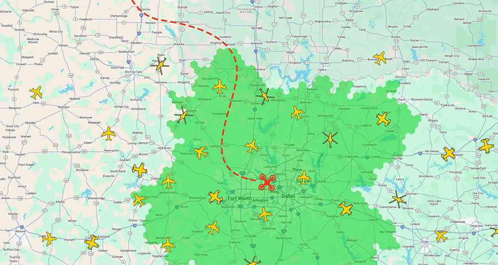
INVOLI.live is an air traffic detection platform that allows drone operators to detect low altitude airplanes and helicopters in Dallas, Texas. This free web-based tool provides a great deal of info about the aircraft and operation, including specifics like the ICAO code and position of the aircraft, allowing operators to make important decisions like whether to take off or abort a mission. A live coverage map shows the reliability of the detection.

Manu Lubrano, Co-Founder and CEO of INVOLI, mentioned that the enhanced situational awareness of the platform will enable safer drone operations in the short term, but we wanted to learn more about the opportunities that this platform is set to open up in the present and future. We asked him how this new platform compares to others, whether or not insights from Dallas can be applied in other locations, what it means to best assess situational awareness needs and much more.
Jeremiah Karpowicz: What are some of the most significant operational challenges that arise when operators do not have the situational awareness they actually need for a given task or project?
Manu Lubrano: Without proper situational awareness, drone operations become inefficient, costly, and difficult to scale. Limited air traffic visibility restricts operational range, forcing operators to fly in smaller, safer zones rather than maximizing their full potential. This leads to inefficiencies and limits the ability to scale operations, ultimately reducing business opportunities and increasing costs per flight. In environments where optimizing resources is key—such as inspections, deliveries, or emergency response—this lack of efficiency directly impacts profitability and long-term viability.
Beyond operational setbacks, safety remains a major concern. Without real-time awareness of surrounding air traffic, the risk of airspace conflicts increases, potentially causing flight disruptions or even accidents.
This is where INVOLI’s solutions provide a decisive advantage. By delivering real-time air traffic data, automated alerts when an aircraft enters the drone operator’s airspace, and comprehensive airspace awareness, we enable drone operators to fly with confidence—optimizing flight paths, expanding operational areas, and ensuring compliance with airspace regulations. In fact, INVOLI’s customers have reported doubling their operational range, unlocking new market opportunities, and significantly reducing operational costs. Whether supporting BVLOS operations, urban drone deployments, or complex industrial inspections, INVOLI helps operators maximize efficiency while maintaining the highest safety standards.
What new capabilities does INVOLI.live have that other air traffic detection platforms do not?
INVOLI.live goes beyond traditional air traffic detection platforms by providing an unparalleled level of visibility at low altitudes—where drones operate and where existing surveillance solutions, like radar, often fall short.
Unlike conventional systems that primarily monitor higher airspace, INVOLI.live is designed as a turnkey air traffic detection solution that enables safe and scalable drone operations. It provides everything needed for real-time situational awareness, from hardware deployment to data processing and integration, allowing drone operators to meet safety and regulatory requirements effortlessly.
A key advantage of INVOLI.live is its tailored coverage for very low-altitude operations, ensuring reliable surveillance where traditional radars and ADS-B networks lack reach. By integrating multiple data sources, including manned aircraft transponders such as ADS-B, Mode S, Mode A/C, UAT, and FLARM, combined with proprietary ground-based receivers, INVOLI.live delivers a comprehensive, real-time airspace picture that significantly enhances operational safety and efficiency.
Another standout feature is its advanced multilateration (MLAT) technology, which allows accurate positioning of aircraft even when ADS-B is unavailable—an essential capability in environments where many aircraft remain unequipped with transponders. Additionally, INVOLI.live offers real-time system status and coverage monitoring, giving drone operators instant visibility into whether the network is operational. This transparency builds confidence in the system, reduces uncertainty, and enables informed decision-making before and during critical missions.
To further support automation and scalability, INVOLI.live features a fully open REST API, allowing seamless integration with third-party aviation systems, UTM platforms, and drone service providers. The platform is backed by a high-reliability Service Level Agreement (SLA), ensuring dependable performance for mission-critical drone operations.
With INVOLI.live, drone operators don’t just gain access to air traffic data—they get a complete, operationally proven solution that expands their range, enhances safety, ensures compliance, and unlocks new business opportunities. By providing real-time, precise, and scalable airspace awareness, INVOLI.live empowers operators to push the boundaries of drone operations with confidence.
Will these capabilities help change expectations around airspace awareness in a way that tangibly impacts or benefits the wider drone industry?
Enhanced airspace awareness is transforming the drone industry, setting new expectations for safety, scalability, and operational efficiency. With solutions like INVOLI’s, operators can confidently expand their capabilities, unlocking BVLOS operations and complex drone missions that were previously constrained by airspace limitations and regulatory uncertainty. By improving safety, reducing collision risks, and strengthening public trust, this technology is paving the way for widespread drone integration into daily operations.
Beyond immediate operational benefits, real-time airspace data is a game-changer for regulatory compliance. As new regulations are set to streamline and facilitate the scaling of drone infrastructure, having reliable surveillance and air traffic awareness will be crucial for meeting evolving requirements. The goal is clear: to remove the barriers that have long restricted advanced drone applications, enabling more ambitious, revenue-generating operations across industries.
Do you envision learning or insights from how this works in Dallas can transfer to other locations?
Dallas serves as a blueprint for scaling up drone operations and deploying air traffic awareness infrastructure efficiently. Through this deployment, drone operators are already leveraging real-time air traffic data to safely conduct BVLOS flights, optimize their operations, and expand their service areas. By providing reliable situational awareness, INVOLI enables safer, more predictable, and commercially viable drone operations, opening the door to new business opportunities.
Beyond immediate operational benefits, the Dallas deployment is a key stepping stone for making our system as scalable as possible. We are refining best practices for fast, efficient receiver deployment, optimizing network coverage, and ensuring seamless integration with local infrastructure. The faster we can deploy in new cities, the faster we can support the growing needs of the drone industry as new regulations unlock more advanced operations.
Additionally, this project allows us to analyze real-world urban airspace dynamics, fine-tuning our system to be even more effective in complex environments. By working closely with local stakeholders, including government agencies, drone operators, and telecom infrastructure providers, we are developing a replicable model that can be rapidly adapted to other cities—ensuring that as drone regulations evolve, the industry is ready to scale up efficiently.
What we’re achieving in Dallas isn’t just a local success—it’s a model for nationwide and global expansion, accelerating the future of drone integration at scale.
How do you envision the capabilities of this system could help inform what we eventually see with Part 108?
The capabilities of INVOLI’s system are not just supporting today’s drone operations—they are actively shaping the future of regulations like Part 108. As regulators work toward defining performance-based requirements for BVLOS operations, real-world deployments like ours provide the data and operational insights needed to make those rules both effective and scalable.
One of the biggest challenges for Part 108 is assessing air risk and reducing it as much as possible to enable safe and scalable BVLOS operations. INVOLI tackles this by delivering turnkey air traffic detection systems specifically designed for low-altitude operations, where traditional surveillance solutions like radar often fall short. By providing continuous, high-precision airspace awareness, we equip operators with the tools needed to minimize collision risks and demonstrate compliance with evolving safety standards. This level of situational awareness not only helps individual operators but also provides regulators with real-world data on air traffic patterns and risk mitigation strategies, shaping future requirements that are both practical and effective.
Moreover, as Part 108 aims to unlock commercial drone operations at scale, it needs to balance safety with economic feasibility. INVOLI’s approach—leveraging ground-based infrastructure for broad coverage and rapid deployment—creates a model that is both cost-effective and scalable, ensuring that airspace awareness is accessible not just for large enterprises but also for smaller operators.
By deploying our system in places like Dallas, we are providing regulators with real-world validation of what scalable, cost-effective BVLOS operations look like. These insights will be instrumental in shaping risk-based requirements, defining acceptable levels of situational awareness, and proving that airspace surveillance solutions can be deployed rapidly to meet the industry's evolving needs.
Ultimately, Part 108 is not just about regulations—it’s about enabling the drone industry to scale responsibly. INVOLI’s system is proving today what will become the standard tomorrow, helping unlock new business opportunities and making complex drone operations a reality.
What are some of the questions that operators and organizations should be asking of themselves or their teams when they're assessing their situational awareness capabilities and needs?
When assessing situational awareness capabilities, operators and organizations should be asking themselves one fundamental question: Do we have the airspace visibility needed to operate safely, efficiently, and at scale?
To break this down, they should consider:
Are we aware of all air traffic that could pose a risk to our operations? Many traditional solutions only detect ADS-B-equipped aircraft, leaving critical blind spots. A truly effective system should provide a comprehensive view of low-altitude airspace, including non-ADS-B aircraft.
Can we confidently operate BVLOS under current and future regulations? As new frameworks like Part 108 emerge, operators must assess whether their situational awareness solution meets performance-based safety requirements and enables scalable BVLOS operations.
How much uncertainty do we face when launching a mission? If an operator must hesitate, take unnecessary precautions, or operate in overly restrictive zones due to a lack of visibility, their business is losing efficiency. A strong situational awareness system should provide real-time, actionable intelligence to maximize operational range and reduce costly delays.
Is our airspace awareness solution scalable? Drone operations will only grow in complexity. Organizations must ask whether their current solution can adapt to new locations, expanding operations, and evolving regulatory requirements without expensive overhauls.
Are we leveraging the best available technology for our specific needs? A one-size-fits-all approach doesn’t work in low-altitude airspace. Operators should look for turnkey, aviation-grade solutions that are designed specifically for drone operations, rather than repurposing tools meant for traditional aviation.
Do we have full visibility into our own surveillance coverage? It’s not enough to have a detection system—operators must also know whether their coverage is active, reliable, and sufficient for the mission at hand. A system like INVOLI.live, which provides real-time monitoring of surveillance coverage, ensures that operators can launch missions with confidence.
By asking these questions, drone operators and organizations can move beyond basic compliance and build a robust, future-proof airspace awareness strategy that supports business growth, unlocks new revenue opportunities, and ensures safe, scalable drone operations.


Comments