

A new “Detect and Avoid” (DAA) platform  which identifies and tracks drones and other aircraft, brought another dimension of safety and security to last week’s Farnborough International Airshow.
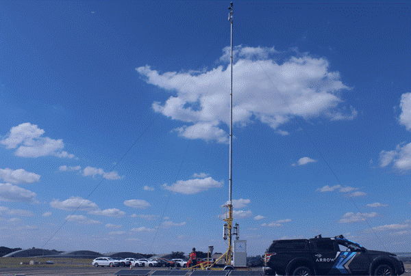
The Arrow ground-based DAA, deployed in partnership by NATS Services, the commercial arm of the UK’s leading air traffic services company and Altitude Angel, the world’s most trusted UTM (Unified Traffic Management) technology provider, continuously monitored the airspace, notably aircraft operating at lower levels.
Lower-level traffic can be difficult to track using traditional radar systems, and Arrow has been developed by Altitude Angel to ensure safety of all users by detecting authorised and unauthorised traffic – including drones. It is making ‘flying under the radar’ a thing of the past.
Authorities at the show had real-time access to the data gathered by the Arrow towers; NATS and Altitude Angel were able to demonstrate the capability of the technology.
Richard Ellis, NATS Head of New Airspace Users, said: “A pop up service like this one is a great example of how safety can be achieved in very complex environments where non-cooperative drone activity can have a real impact on an airshow. It’s a privilege to be able to demonstrate the capability of the Arrow technology with the authorities at a premier event such as Farnborough Airshow.”
Richard Parker, CEO of Altitude Angel, added: “Working alongside Farnborough International and NATS Services over the course of a very busy airshow is great validation of the performance – and range – of the sensor and software technologies we’ve developed. The Airshow is a very busy airspace environment, attended by crowds of hundreds of thousands; our Arrow towers, deployed in just a matter of hours, demonstrated an ability to provide vital intelligence to the authorities, a service that can help to safeguard very complex events.”
The Arrow capability, deployed in the Airshow grounds, collected data from a deployment of road-towable mast-based sensors to create a view of lower-level airspace within Farnborough Airport’s flight restricted zone (FRZ) and beyond. The infrastructure was completely self-sufficient, including generation of its own (solar) power and a private communications network, only requiring minimal space from the Airshow organisers. This picture included real-time visibility of non-electronically conspicuous aircraft and drones, those which don’t carry traditional transponders, fused into a single airspace picture.
Alex Culley, NATS GM Farnborough Airport, said: “Our focus during the airshow is to ensure a safe event for visitors and participants and minimal disruption to our neighbouring airspace users. We need a robust and comprehensive view of all traffic moving in and out of the airshow and new technology solutions can help enhance safety, security, and operational efficiency within the airspace.”
Source: Altitude Angel


Comments