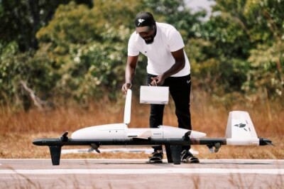
Recently, Skyward added automated flight modes for pre-planned missions and surveys within its InFlight mobile app. Additionally, the company released a new guide on how to achieve buy-in from executives and work with risk managers, compliance, health and safety, and legal teams.
Released in 2019, Skyward’s inFlight mobile app works as a complete ground control system (GCS) offering advanced airspace intelligence and flight planning features to streamline operations between the office and the field. To enhance every user’s experience, Skyward continues to launch new features, such as operation planning and mobile LAANC requests introduced in late 2019, and Live Flight Tracking for remote program oversight & risk mitigation earlier this year.
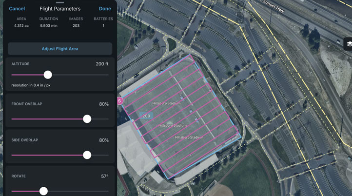
With the new automated flight modes, Skyward users can fly automated missions, collect imagery, data, or videography, and automatically log flights to Skyward without leaving InFlight. Together with the previously mentioned features, planning flights, requesting airspace permission, running a risk assessment, and controlling a flight becomes a simplified process. Within the Android and iOS app, users will now find three automated flight modes: Survey, Orbit, and Point to Point.
By creating an automated path around a point of interest, the Orbit mode provides 360-degree footage of a site or structure, and the images collected can be used to help create 3D models.
Designed for a diverse array of use cases, including surveying, inspection, and construction progress tracking, Point to Point flights allow the drone to automatically fly along a user pre-defined path.
For companies conducting orthomosaic or lidar point cloud surveys, the Survey mode automatically creates a flight path for three-dimensional mapping based on the area of operation and autonomously flies the mission.
In a recent blog post, Mike Morris, Customer Success Manager at Skyward, describes how to plan a flight area, plan an automated drone survey, fly an automated drone mission, and process drone collected data to create a 2D orthomosaic map using Skyward’s automated Survey mode. However, “orthomosaic maps are only the beginning,” Morris wrote. “With the right processing tools, you can also create 3D survey maps, and InFlight’s survey mode can be optimized for lidar surveys.”
Founded in 2012, Skyward is constantly looking to develop solutions to perform tasks in faster, cheaper, and safer ways, and to spread its knowledge within different subjects of the drone industry. Along with all the webinars, white papers, and case studies the company regularly publishes, there are also various guides exploring best practices for drones in different industries and how to set up a drone program.
Adding Drones to the Enterprise, the company’s newest guide, brought Skyward’s executives, lawyers, and accountants together to explain how someone can present business value, collaborate with compliance teams, risk mitigation, and provide transparency when launching or scaling a drone program. The guide focuses on three major topics: Gain Executive Buy-In, Working with Legal & Corporate Compliance, and Build an Ongoing Relationship with Risk Management.
To gain buy-in from executives, it is crucial to understand what kind of deliverables they need and understand the business problem that drones will solve. After that, creating a committee of stakeholders to discuss drone technology and identify how it might be incorporated helps to find other potential use cases throughout the entire company. Moreover, it’s important to start small and not try to tackle multiple use cases all at once.
“Don’t assume that your executives already understand the value that drones can provide,” the guide reads. “The data that your executives find most compelling will depend on your company, the industry, and the individuals involved."
Once the company is ready to scale, proving value, ensuring scalable ongoing operational excellence, safety, and efficiency, managing data, building strong internal systems, and expanding the fleet and pilots are some of the steps needed to succeed.
Furthermore, ensuring full compliance with national airspace regulations and local ordinances, and providing full transparency into the drone operation are some of the main goals when adding drones to the enterprise. To create a compliant drone program, compliance needs to be integrated into the workflow and can’t be “an afterthought limited to annual training videos regarding IT security or ethical business practices”. For a commercial drone program to work, a comprehensive general operating manual is essential to help follow standard operating procedures and reduce risks.
Finally, it’s important to build an ongoing relationship with risk management teams and show them drones may decrease the company’s net risk. The guide talks about the five best practices to reduce overall risk, including the creation of maintenance protocols and pilot training programs, keeping flight data in a centralized location, having a strong culture of accountability in a drone program, and having a drone insurance plan.


Comments