

Telespazio Ibérica actively contributes to environmental protection, disaster response, and climate change monitoring through advanced geoinformation services. The innovative projects and technologies highlighted below show how Telespazio Ibérica brings space technology closer to Earth.
 A geospatial solutions provider with over 35 years of experience, Telespazio Ibérica has strong cartography and remote sensing roots. The company is part of Telespazio, a joint venture between Leonardo and Thales, that operates in key sectors such as geoinformation, satellite communications, and navigation.
From its offices in Spain, Telespazio Ibérica provides advanced services of the value chain covering the entire asset management cycle, from map generation using the latest technologies to software development, integrating Geographic Information Systems (GIS), satellite communications (SatCom), and Advanced UAS Services.
The company serves high-tech sectors such as defense, energy & utilities, telecommunications, public administration, transportation, emergency services, and large corporations, offering cutting-edge solutions tailored to the evolving needs of these industries.
Addressing global sustainability challenges
Telespazio Ibérica is committed to using space technologies to address global sustainability challenges. The company actively contributes to environmental protection, disaster response, and climate change monitoring through advanced geoinformation services.
One key example is its collaboration with the Copernicus Emergency Management Service (EMS) Rapid Mapping program. Here, Telespazio Ibérica plays a crucial role in land monitoring, natural disaster assessment, and environmental protection. The company’s remote sensing capabilities support efforts in deforestation monitoring, biodiversity conservation, and climate impact analysis, helping make data-driven decisions. Using satellite imagery, the company produces maps to help the emergency services.
Technological advancements overview
Telespazio Ibérica continues to play a significant role in advancing space technologies and their practical applications in various sectors, by continuously innovating in geospatial intelligence, satellite data analytics, and UAV-based solutions. Some of its latest advancements include:
- Advanced SAR (Synthetic Aperture Radar) Processing: Leveraging data from COSMO-SkyMed satellites, Telespazio Ibérica provides high-resolution radar imaging for applications in urban planning, infrastructure monitoring, and defense.
- AI-Powered Remote Sensing: The company integrates Artificial Intelligence (AI) and Big Data to enhance the processing of satellite images, improving land classification, vegetation health assessment, and maritime surveillance.
- UAV Integration with Satellite Data: Through the Civil UAV Initiative in Galicia, Telespazio Ibérica is developing UAV-based solutions for biodiversity monitoring, precision agriculture, and emergency response, combining drone and satellite imagery for more accurate analysis.
- Geospatial Solutions for Utilities and Energy: The company works with leading companies such as Naturgy and Enel to provide GIS-based asset management and risk assessment solutions, improving the efficiency and sustainability of power networks.
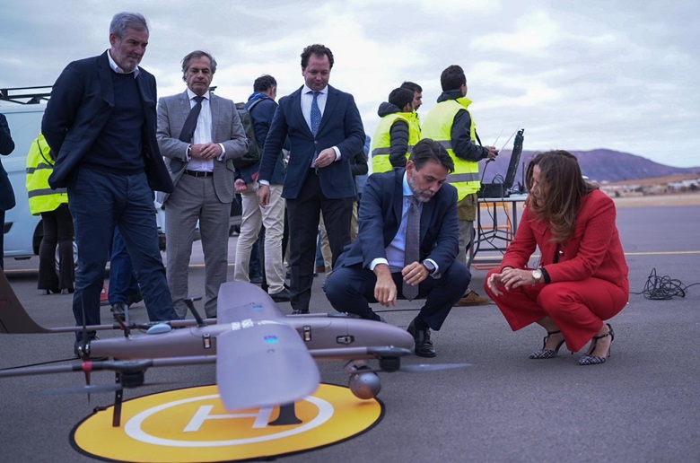
- ISSEC – Innovative Solutions for Biodiversity, Security, and Public Services: As part of the Canarias Geo Innovation Program 2030, Telespazio Ibérica is involved in R&D&I projects for the monitoring, observation, and management of biodiversity, focusing on wildfire prevention, environmental protection, and hospital logistics. The initiative leverages aerospace and aeronautical technologies to address critical challenges in these areas. For that purpose, this summer Telespazio Ibérica will be using Leonardo’s Falco EVO in Fuerteventura island, a MALE (Medium-Altitude Long-Endurance) remotely piloted aircraft with a +20 hours endurance.
Providing intelligence and predictive analytics
Telespazio Ibérica has observed a clear shift in the Earth Observation (EO) industry from providing raw satellite imagery to offering integrated data-driven services. Customers today demand actionable insights rather than just images, pushing companies like Telespazio Ibérica to develop end-to-end solutions that include:
- AI-enhanced image processing to automatically detect land changes, environmental risks, or infrastructure anomalies.
- Customized analytics dashboards for clients to monitor key variables in real-time.
- Integration of satellite and UAV data for more precise and localized decision-making.
This evolution reflects a broader industry trend where EO is no longer just about image delivery but providing intelligence and predictive analytics to support business and government operations.
The benefits of satellite and drone imagery
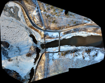
Satellite imagery efficiently covers vast areas, making it ideal for land monitoring, climate change analysis, and disaster management. It also provides historical data sets, enabling organizations to track changes over time, and can capture data even in remote or restricted areas where drone flights are impractical.
On the other hand, drone imagery offers higher spatial resolution for localized inspections, such as infrastructure assessment and precision agriculture. It provides real-time insights and on-demand data collection for immediate response, complementing satellite data, especially for detailed analysis in critical zones.


Comments