In 2007, the European Union created the Single European Sky (SES) initiative to implement a pan-European approach to air traffic management (ATM). As part of that initiative, the Joint Undertaking known as SESAR (Single European Sky ATM Research) was formed. This agency has been working to not only increase efficiencies to the existing ATM system, but also to integrate unmanned aerial vehicles (UAV) into the crowded skies over Europe. This overall effort is known as U-Space and we’ve been hearing talk about what the creation of this ecosystem would look like for years now. Thankfully, we’re finally past talking about these logistics and are ready for real-life tests around them.
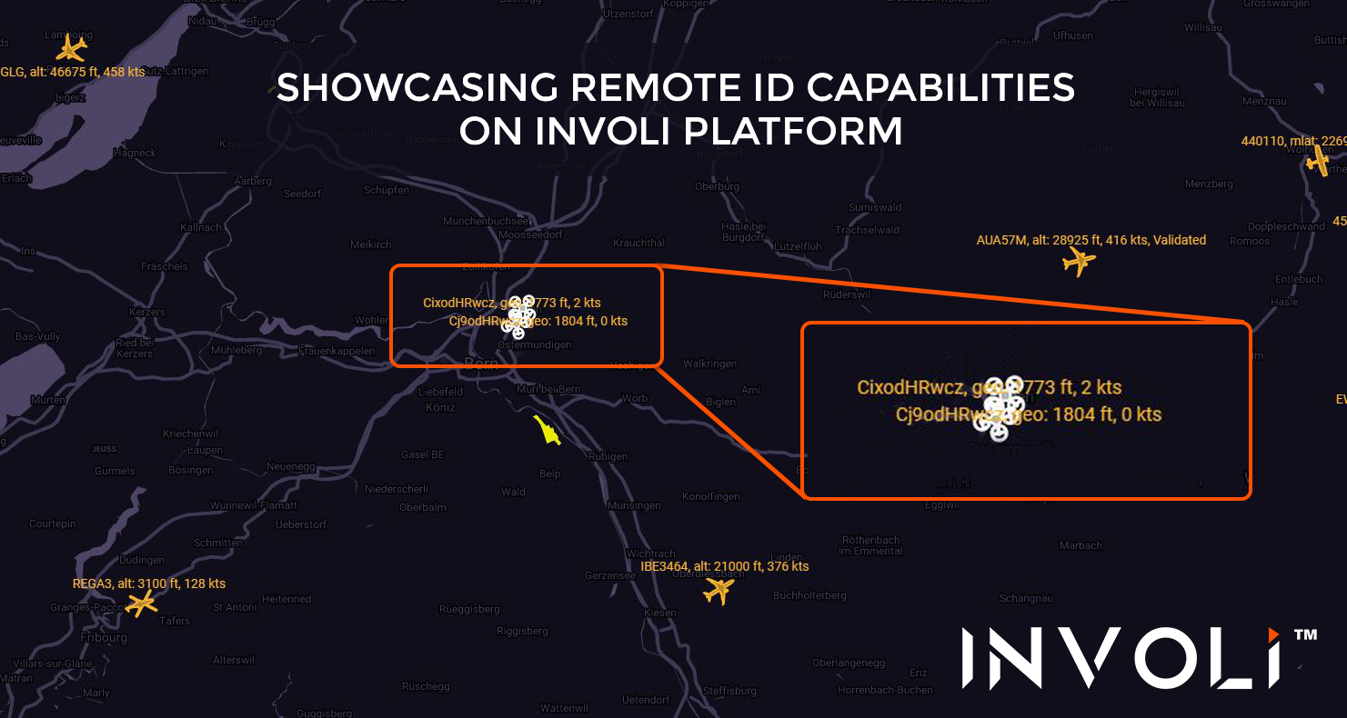
Recently, the Swiss company INVOLI helped to successfully showcase the remote identification of drones (Remote ID) capabilities on its platform during a joint demonstration which took place in Bern. The overall effort was driven by various members of the Swiss U-Space Implementation (SUSI) that include ANRA, AirMap, Orbitalize, and Wing.
INVOLI is a multi-award-winning Swiss company with a mission to safely and efficiently open the sky to all flying objects. They have developed a patented hardware-software system that integrates advanced artificial intelligence and space technologies into drone air traffic management systems.
Known in the USA as Unmanned Traffic Management or UTM, U-Space designates a set of services and procedures that are designed to enable the safe integration of drones into the airspace. The goal of U-Space is to organize and manage the airspace and to allow the growth of this nascent industry alongside the aviation world, safely for everyone. Doing so will provide everyone with the situational awareness, data exchange and digital communication capabilities and standards that are needed to define a European drone ecosystem.
The Swiss implementation of U-Space, SUSI, is a successful application at a national level, having integrated all relevant stakeholders into the discussion from authorities, drone industries and telecom industries. This collaborative effort is notably coordinated by the Swiss Federal Office of Civil Aviation, with the participation of skyguide (the Swiss Air Navigation Service Provider), and a growing group of industry stakeholders.
The demonstration was held with the aim of showing to the public that drones can be remotely identified. Interested persons can register into a platform where drones are displayed in order to match the drones shown on the platform with the ones flying above them. Authorities will also be able to effectively monitor the airspace to ensure the safety of everypone in the air and on the ground.
During the demonstration, the INVOLI interface displayed the position of the drones that were participating in the demonstration, based on data received from Wing, whose system allows U-Space providers to exchange information with respect to the drones connected to each of their platforms. In doing so, every U-Space provider can the same information on the flying drones, all of which will be made available to the right people as necessary.
“The demonstration was a success, both from a technological and collaborative perspective: different technologies were put to work together and so were the people behind it, coming from different areas of the industry and from different corners of the world," said Manu Lubrano, CEO & co-founder of INVOLI. "It's a big step for the drone industry and for INVOLI to showcase its capabilities along such big industry names, and all in front of authorities, police and the likes.”
U-Space is defining what the safe integration of unmanned vehicles into a crowded airspace can look like on a technical level. Doing so will allow a whole new industry to expand its services in a safe and efficient manner.


Comments