

One of the biggest challenges of autonomous vehicles, regardless of the type of operations, ground, marine or aerial, is the fact that the required technology must combine the topographic reality of the terrain with the rules that guide the use of the specific environment. In the case of ground vehicles, navigation of streets needs to be combined with traffic rules, including stop signs, and every other restriction that might affect the correct, and legal, use of the occupied roads.
But when we deal with autonomous operations in the National Airspace (NAS), we not only add a third dimension to the equation, but also the fact that the sky is heavily divided into classes and contains thousands of particular rules that allow aircraft of all types to navigate safely and with established separations. This is especially important when operating beyond the visual range of the operator, or pilot in command (PIC) in what is known as BVLOS flights.
So, the challenge for autonomous aerial vehicles is to have access to all that updated information at all times in real time. Even though most airspace is set and varies little, the aviation charts suffer constant updates, including airport restrictions, NOTAMS (Notice to Aviators), temporary flight restrictions (TFRs) and many others.
For remotely piloted aircraft (RPAs) to navigate the NAS safely and legally the technology guiding their path will have to combine hyper accurate topographical maps with up-to-date aviation charts in order to avoid collisions with fixed and moving objects.
A company in France, Stratomaps, has managed to combine these two disparate sources of data into a seamless stream of navigation information that allows autonomous uncrewed aerial vehicles (UAVs) to perform their missions avoiding ground features and complying with the aviation rules of the regions in which they operate.
 We had the opportunity to connect with Yvan Montalieu, Founder and CEO of Stratomaps, for an interesting conversation about this valuable tool for current operators and the upcoming era of BVLOS flights.
“Our company, Stratomaps, was born out of the belief that we stand on the brink of a new era, where Uncrewed Aerial Vehicles will become a mainstream mode of transportation,” Yvan said. “The number of drone flights Beyond Visual Line of Sight (BVLOS), such as large-scale infrastructure inspections, surveillance, rescue operations, delivery of medical supplies, and Advanced Air Mobility (AAM), will only be allowed by the regulator if they pose minimal airborne, ground risks and annoyance to the population.”
The main challenge for this type of technology, is that it is required to be accessible to the UAV or AAM at all times and the amount of data is too large for a complete download onboard, therefore communications and ease of transmission and reception are a key ingredient for its success for the current state of the technology, but Stratomaps is working on an ingenious alternative.
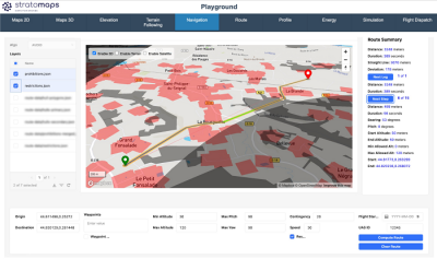
“Our goal at Stratomaps is to process and aggregate UAVs ground and air data for specific operation zones,” Yvan reported. “The data can be visualized using interactive 3D maps, extracted in file formats ready for import into the drone’s ground control system/Autopilot and can also be made available as geospatial products through a suite of APIs.”
Stratomaps has defined its impact in three distinctive categories:
Help improve safety by:
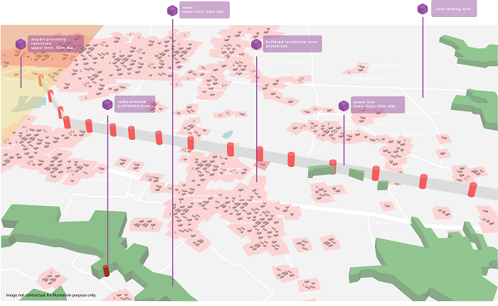
- Providing high-quality maps for specific operation zones,
- Computing 3D routes that minimize risks.
Help reduce carbon emissions by:
- Computing energy efficient routes,
- Optimizing deliveries and infrastructure inspection missions.
Help mitigate societal impact of UAVs by
- Recommending routes that limit public disturbance,
- Defining new maps with dedicated UAV corridors.
The Stratomaps technology accomplishes these goals through a series of algorithms that allows it to plan, validate, and optimize routes, as well as create geographical awareness that permits the autonomous vehicle to navigate the NAS and follow the terrain in a safe manner.
“We are aware that these are ambitious goals for our technology, but anything short of that will not be enough for the regulators of the world such as the FAA in the USA and EASA in Europe to allow BVLOS flights,” Yvan said. “We are currently focusing on the business-to-business sector (B2B) and offering our solution as a Software as a Service (SaaS) in order to enable drone manufacturers to focus on their aircraft and allow Stratomaps’ solution to handle the navigation portion of the business workflow.”
When the conversation turned to the future, Yvan was cautious but also optimistic about the possibilities for enhancement of the current version.
“The amount of data involved in autonomous aerial navigation is enormous, and we need to be very careful as we add layers of complexity to our complete solution,” Yvan cautioned. “Our current version can have digital elevation data, ground vectorized maps and UAVs specific aviation data but our goal is to have a version that will also include more features such as wind and network cellular coverage to help operators guide and plan their routes more efficiently.”
There is no doubt in our minds that if we are ever going to have a safe integration of uncrewed and crewed aircraft in the NAS, a system like Stratomaps will have to be mandatory in order to ensure that every aircraft sharing the sky will have the same information and the same access to communications.


Comments