

Many industries have benefited from the availability and affordability of uncrewed aerial vehicles (UAVs) as applications for cost reduction and personnel safety increase. But how about the scientific community? There must be hundreds if not thousands of examples of independent scientists and universities around the world using these uncrewed marvels to perform complex science experiments using new approaches.
We tend to look at industrial and commercial applications for drones, but pure science is also benefiting from the affordability and availability of aviation, at a time when budgets are tight and completion time of experiments is key.
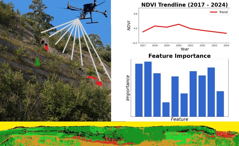
This is the case of several scientists in Poland who cooperated to make a comprehensive study of coastal erosion, using a number of new technologies, including airborne lidar and bathymetry.
Paweł Tysiąc and Rafał Ossowski from the Faculty of Civil and Environmental Engineering, Gdańsk University of Technology, teamed up with Łukasz Janowski from the Maritime Institute, Gdynia Maritime University, and Damian Moskalewicz from the Department of Geomorphology and Quaternary Geology, Faculty of Oceanography and Geography, University of Gdańsk, to finally make a comprehensive study of the coastal erosion of a sector of Poland’s coast, more specifically 1 mile of the Southern Baltic Sea.
The paper titled “Utilizing UAV and orthophoto data with bathymetric LiDAR in google earth engine for coastal cliff degradation assessment.” It was published in “Scientific Reports, January 2025” and represents a clear example of new technologies being used to gather data that is vital to understand nature’s way of changing our geography.
We had the opportunity to talk to Paweł Tysiąc, one of the authors of the study, to better understand the impact that drones and lidar had on their project.
“Traditional methods of monitoring cliff erosion often involve labor-intensive fieldwork and complex calculations of spatial point distributions using traditional land surveying techniques,” Paweł said. “In contrast, recent advancements in remote sensing and machine learning offer new methodologies for assessing cliff degradation with greater efficiency and precision.”
Coastal degradation is an issue that has caught the attention of governments and scientists around the world given the increase in the number of natural disasters and the ever-growing damage that each occurrence inflicts on the population and by default in the geography.
 “In this paper, we broadly use the term ‘cliff degradation.’ We define it as an overall, eventual effect of erosional coastal cliff change induced by multiple factors and processes, including e.g., complex lithological and hydrogeological settings, storm surge wave activity, rainfall, wind blow, human activity, that lead to the development of mass movements and their effects like e.g., landslides, faults, cracks and screes,” Pawel said. “Based on this, a key premise of this study is that the electromagnetic wave reflection spectrum differs in areas affected by degradation. In the case of coastal cliffs, changes in material aggregation, vegetation, and other factors result in noticeable differences.”
Remote sensing is nowadays a standard method for monitoring coastal environments. By utilizing various types of imagery and data collected from satellites, aerial platforms, and ground-based sensors, researchers can obtain detailed and up-to-date spatial information about coastal zones. Timely resolution framed images allow for the observation of changes in coastal morphology over time, helping to identify areas most affected by natural disasters. In this case, the authors used aerial photography, which provides high-resolution images that are invaluable for detailed before-and-after comparisons. However, there is a problem with different illumination time on images, resulting in different processing objects. In terms of photogrammetry, the flights need to be performed in similar conditions, but some problems of seasonal changes persist in this matter.
“We decided to use lidar as an alternative to combat the ever-changing lighting conditions,” Pawel reported. “Lidar data is crucial for measuring changes in coastal topography with high accuracy, helping in filtering data from vegetation, or isolated points. The most important products from lidar are Digital Elevation Models (DEMs), which are used to create 3D representations of coastal landscapes. 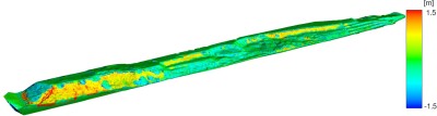 These models help in understanding the spatial distribution of erosion through computation between models from different periods of time.”
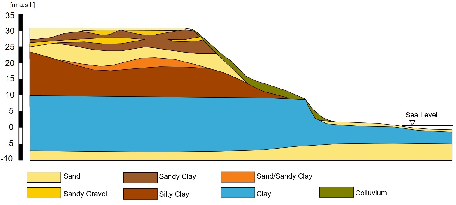
The problem arose that the component of coastal degradation that was happening underwater played an important role in the reasons why the phenomenon was taking place, therefore the decision was made to also use lidar as a bathymetry tool.
“The findings provide insights into how coastal cliffs may respond to ongoing and future climate change, particularly in terms of sea-level rise and increased storm activity,” Pawel stated. “By enhancing traditional geotechnical surveys with proposed advanced remote sensing techniques, such as the use of UAVs and airborne measurements, offers a model for other regions facing similar challenges. The insights gained from this study can inform coastal management policies, not only in Poland but also in other regions with similar geological and environmental conditions. Effective management plans based on such studies can help mitigate the risks to human life and infrastructure posed by coastal cliff erosion and instability.”
By combining aerial and maritime information gathering by autonomous vehicles, this group of scientists were able to improve the quality of their data, the precision of their conclusions, and the adequacy of the actions to be taken to mitigate the damage to geography and inhabitants of the affected areas.


Comments