

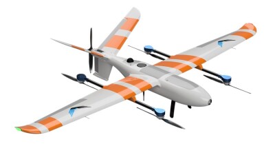
Censys Technologies now offers the Mapper+ Version C, YellowScan’s cutting-edge UAS LiDAR system. Integrated with the Sentaero 5,  this new payload introduces new features that enable enhanced LiDAR capabilities.
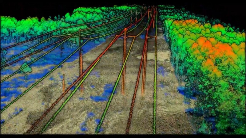
Censys extends its utility across a variety of applications by merging BVLOS (Beyond Visual Line of Sight) missions and operations over moving vehicles and people with the ability to seamlessly acquire colorized point clouds in a single flight.
The Mapper+ Version C payload enhances operational efficiency for a variety of applications, including surveying, mapping, utilities, and environmental sciences, by reducing the number of flights needed, payloads, and data processing time.
“My interests lie in the creation and analysis of digital twins, capturing reality in its truest form,” said Bobby Valentine, Owner of Valentine Brand LLC. “The Yellowscan Mapper+ is the perfect solution to achieve this type of mission with its compact and lightweight design I can fly for extended periods of time all while capturing five return data effortlessly.”
This LiDAR system combines an 8-megapixel RGB camera with a LiDAR sensor. It provides precision of 3.5 cm, accuracy of 4 cm, a laser range of up to 230 m, a 70.4° x 4.5° scanner field of view, up to 240,000 shots per second, and up to 10 Hz of scanning frequency.
“With the Sentaero 5 capable of long-linear data collection, as well as wide-area survey and mapping projects, having multi-sensor capability increases overall efficiency per project. By not having to run multiple flights to colorize point clouds, operators can achieve high-quality deliverables in less than half the time,” said Kyle Miller, Director of Sales at Censys Technologies. “This equates to higher ROI per project, reduced costs, and overall operational safety, spending less time in the air.”
To learn more about Censys Technologies’ payload and geospatial mapping technology offerings, please contact us at [email protected] or visit censystech.com.
About Censys Technologies: Censys Technologies is a leading provider of uncrewed aerial systems, specializing in the development and production of innovative BVLOS drones for various industries. With a focus on advanced technologies and user-centric design, Censys Technologies strives to deliver at the edge solutions that revolutionize the way businesses operate. For more information, visit censystech.com.
Source: Censys


Comments