

This week’s “Around the Commercial Drone Industry” news round-up looks at recent news regarding a possible ban on DJI drones in the US, a company using drones for tracking endangered species, and an effort in Oklahoma to improve drone-based weather forecasting.
Is the DJI Ban Back on the Table?
Last week, Commercial UAV News reported that the US Senate Armed Services Committee released its version of the National Defense Authorization Act 2025 (S. 4638, NDAA FY25) that did not include the Countering CCP Drones Act—the law calling for a nation-wide DJI ban.
However, since publishing this piece, Senator Rick Scott (R-FL) has submitted an amendment to have the Countering CCP Drones Act included in the Senate's version of the 2025 NDAA. At present, the amendment has not yet been formally accepted into the bill, but the amendment is co-sponsored by Senator Mark Warner (D-VA), making it bipartisan, and that could lead to its acceptance.
Watch Commercial UAV News in the days and weeks to come for regular updates on this important issue.
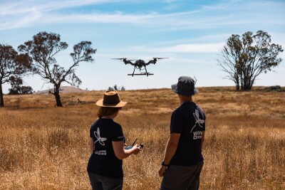
Endangered Species Tracking by Drone
From LinkedIn comes information on an Australia-based company that uses drones to “track the movements of some of the world’s most endangered species.” Led by ecologist Dr. Debbie Saunders, Wildlife Drones has developed an “innovative drone tracking technology” in which animals are tagged with VHS radio tags, and drones are flown to monitor their movements. The firm operates around the world, with recent projects involving the tracking of bats, pangolins, koalas, kakapos, and rhinos.
Drone-Based Weather Forecasting in Oklahoma
Fox 23 in Tulsa, Oklahoma reported on a new effort between the National Weather Service Tulsa and Boston-based GreenSight to deploy an uncrewed aircraft system to “evaluate the boundary layer by measuring the temperature, humidity, barometric pressure and wind speed and direction.” Central to the project is the WeatherHive, a charging station that will service 10 nanodrones called WISPS. These nano-drones will be used to drones to fly 50-minute missions to collect data while weather stations on the ground will be used to product “a 3D model of how the atmosphere is behaving.”


Comments