

AISPECO designs and builds advanced geospatial data collection platforms. It differentiates itself by focusing on integrality, flexibility, and global accessibility.
AISPECO was initially established as an aerial survey service provider, specializing in UAV-based geospatial data collection across Europe. Over time, the company transitioned from conducting surveys to developing its own systems and competing in tenders. When COVID-19 restrictions disrupted cross-border operations, AISPECO made a strategic shift to focus entirely on hardware manufacturing.
Today, AISPECO designs and builds advanced geospatial data collection platforms, featuring versatile multi-sensor payloads for airborne, mobile, and stationary applications. Its solutions integrate LiDAR, hyperspectral, and other imaging technologies to support industries such as utilities, forestry, city mapping, agriculture, railroads, defense, thermal imaging, bathymetry, mining, and civil engineering.
Multi-sensor systems
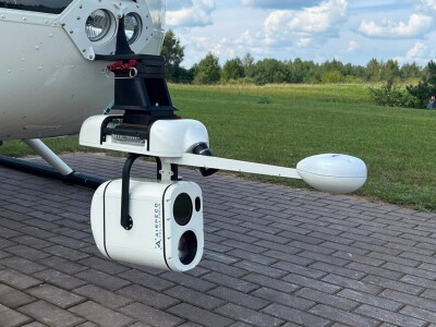
AISPECO offers a range of modular multi-sensor systems designed for airborne, mobile, and stationary platforms. These systems seamlessly integrate LiDAR, hyperspectral, and optical imaging technologies, providing flexible and high-precision solutions for diverse geospatial applications.
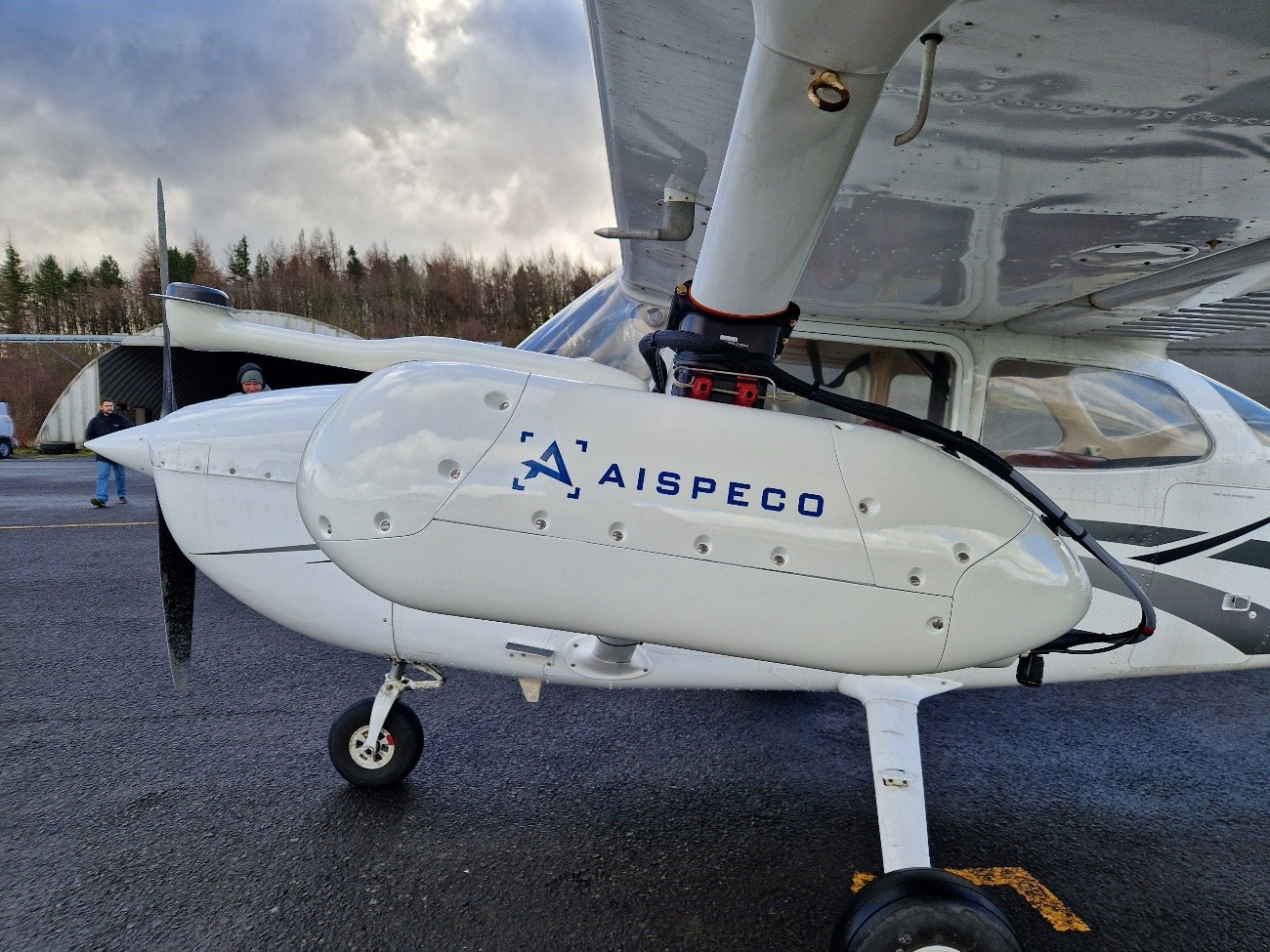
- HELIUX LITE – A modular airborne system designed for aircraft like Cessna and helicopters like Robinson, supporting LiDAR and multi-sensor configurations for aerial inspections, mapping, and surveying.
- HELIUX FOCUS – An AI-powered gimbaled system that automatically tracks and captures high-precision imagery of fixed objects during flight, enhancing efficiency in targeted data collection.
- HELIUX ATOM – A lightweight, high-precision payload combining a survey-grade scanner and a high-resolution camera, adaptable for drones, backpacks, or mobile mapping applications.
- HELIUX MINI – A compact airborne system supporting up to three sensors, designed for light aircraft and helicopters, making it ideal for corridor mapping and aerial surveys.
- MOBILE MAPPING – A system that integrates LiDAR, optical, and hyperspectral sensors on vehicles to generate real-time, high-resolution 3D maps for urban planning and infrastructure management.
Seamless transfer and use of components
A defining feature of all AISPECO systems is their modular and upgradeable design. Regardless of which system a client initially invests in, each is built upon a common integration core developed by AISPECO. This allows components such as LiDAR sensors and photogrammetric cameras to be seamlessly transferred and used across different system configurations.
Clients benefit from this design by avoiding the need to purchase entirely new equipment as their operational requirements evolve. Instead, they can simply adapt their existing setup, whether by adding a new pod, integrating additional sensors, or scaling to a more advanced platform – resulting in significant cost savings and increased operational efficiency.
This adaptability empowers users to manage their data acquisition investments more strategically, providing the flexibility to expand into new applications or markets as needed. The interchangeable nature of AISPECO’s systems not only streamlines scalability but also reduces the financial and logistical barriers typically associated with business growth in the geospatial sector.
Drones as advanced geospatial data collection platforms
Drones are highly effective for small areas where high-precision results are required. However, when mapping thousands of kilometers of power lines, gas pipelines, or other infrastructure, drone efficiency significantly decreases, making it necessary to choose alternative technologies. Mid-market solutions are essential in such cases, as they provide high-precision data collection quickly and at the lowest possible cost.
This is where AISPECO comes in. The HELIUX product line is designed for high-precision, high-resolution data collection using light aircraft, which offer relatively low operating costs while handling workloads far beyond the capabilities of drones.
AISPECO supports the following aircraft and helicopter models:
- Diamond: DA42
- Robinson: R44, R66
- Bell: 206 family, 407 family, 205, 212, 412, 429, 505
- MD: MD500, MD369
- Airbus: H120, H125, H130, H135, H145, AS350 family, AS355 family
- Agusta: AW109, AW119
- Sikorsky: S-70
AISPECO creates custom-tailored solutions based on a drone’s payload capacity.
Developing integrated sensor controllers
As mentioned earlier, AISPECO has been operating in the geospatial data collection and processing industry for several years. Throughout this time, the company has gained valuable insights into the gaps in the market, particularly the challenges and high costs associated with collecting and integrating large volumes of quality data. The company also identified that different tasks often require different equipment, and at that time, there was no simple solution available to easily swap sensors for various applications.
This led to incremental product development: product development is driven by firsthand experience in data acquisition, which has enabled AISPECO to create unique solutions tailored to the needs of the market. This approach has allowed the company to remain competitive and offer distinctive solutions. In short, AISPECO evolved from being a customer to becoming a supplier.
Making geospatial easy
AISPECO differentiates itself by focusing on integrality and flexibility. The company believes that geospatial data collection should be customizable to fit each client's specific needs while keeping costs as low as possible. Whether it's adjusting systems for particular applications or adapting solutions to suit the client's existing aircraft, AISPECO ensures its equipment is tailored to the customer’s requirements.
Another key aspect of our approach is global accessibility. Clients don’t need to own an aircraft, which can be costly and come with complex logistics, especially when transporting it internationally. With AISPECO, clients can pack the system into compact, specially designed cases, and transport it as standard check-in luggage. Once at the destination, they can easily rent a local aircraft, install the system, and carry out data collection without any hassle. This significantly reduces the logistical burden and opens up global opportunities for clients to expand their reach and grow their businesses.
As for exciting new fields and applications for geospatial data, AISPECO sees significant potential in urban planning and smart cities, precision agriculture, and environmental monitoring, especially when combined with new technologies like hyperspectral imaging and AI-driven analytics. These fields are transforming sustainability, resource management, and urban development, and the company is excited to be part of that evolution.


Comments