The information you submit will be stored and used to communicate with you about your interest in Commercial UAV News. To understand more about how we use and store information, please refer to our privacy policy.
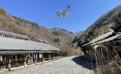
Aerosense started as a joint venture between Sony and ZMP, inheriting technological development capabilities including manufacturing know-how. Today, its drones are used in wide-area long-distance inspections, surveys, patrols, and more.
Aerosense develops and provides industrial solutions utilizing drones, which are flying robots. In August 2015, Aerosense started as a joint venture between Sony Corporation, which was engaged in drone R&D then, and ZMP Corporation, which has been involved in the robotics business since its founding in 2001. The company has an in-house integrated development system from hardware to software and cloud computing, and provides on-site sales, service, and support. Its customers are mainly construction companies and local government.
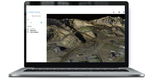
A cloud platform for improving customer business efficiency Aerosense researches, develops and operates a cloud platform that performs specific data analysis required for business processes based on data acquired from drones at various industrial sites, using GNSS technology, AI technology, and more. The system provides analysis results for improving customer business efficiency.
Aerosense's unique and competitive advantage is that it further enhances the convenience and excellence of its drones by integrating various data captured and acquired by drones in surveying and inspection with its cloud platform. This takes advantage of the experience and achievements from many customer sites, advanced development, and manufacturing capabilities.
Another strength of Aerosense is its strategy of connecting to other companies' platforms that handle pre-processing and post-processing for all business processes in each industry through API linkage, making the Aerosense cloud platform a hub for data processing and analysis processes in each sector.
Aerosense started as a joint venture between Sony and ZMP, inheriting technological development capabilities including manufacturing know-how. Today, its drones are used in wide-area long-distance inspections, surveys, patrols, and more.
Aerosense develops and provides industrial solutions utilizing drones, which are flying robots. In August 2015, Aerosense started as a joint venture between Sony Corporation, which was engaged in drone R&D then, and ZMP Corporation, which has been involved in the robotics business since its founding in 2001. The company has an in-house integrated development system from hardware to software and cloud computing, and provides on-site sales, service, and support. Its customers are mainly construction companies and local government.
A cloud platform for improving customer business efficiency Aerosense researches, develops and operates a cloud platform that performs specific data analysis required for business processes based on data acquired from drones at various industrial sites, using GNSS technology, AI technology, and more. The system provides analysis results for improving customer business efficiency.
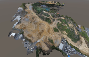
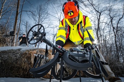
Aerosense data capture
Aerosense's unique and competitive advantage is that it further enhances the convenience and excellence of its drones by integrating various data captured and acquired by drones in surveying and inspection with its cloud platform. This takes advantage of the experience and achievements from many customer sites, advanced development, and manufacturing capabilities.
Another strength of Aerosense is its strategy of connecting to other companies' platforms that handle pre-processing and post-processing for all business processes in each industry through API linkage, making the Aerosense cloud platform a hub for data processing and analysis processes in each sector.
Aerosense Drone Systems Aerosense inherited technological development capabilities from the Sony Group, including manufacturing know-how, highly specialized engineers, and a wealth of experience in drone operation and demonstration testing at customer sites. Its key advantage is the platform technology that establishes the foundation for highly versatile drone development by bringing together and utilizing these capabilities. Aerosense drones are strong in “long range” and “long duration,” and can be deployed in industrial fields where these characteristics are required.
In addition, to solve issues in the field, Aerosense has established a system for conducting research and development using a unique platform consisting of engineering capabilities that can integrate everything from hardware to cloud systems, the use of advanced technologies such as control, signal processing, and artificial intelligence, and the accumulation of autonomous flight experience.
Aerosense offers these two drones:
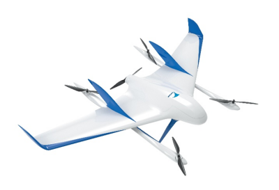
Aerobo Wing
Aerobo Wing (AS-VT01K) VTOL : A fully automatic fixed-wing vertical takeoff and landing drone capable of a maximum speed of 100km/h and a maximum flight distance of 50km. There are a variety of payload attachments available, from cameras to multispectral sensors.
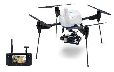
Aerobo PPK (AS-MC03-PPKHL): Equipped with aAerobo PPKdual-frequency GNSS receiver, and post-processing kinematic surveying system, the Aerobo PPK uses Herelink HD Transmission to achieve longer range communication performance than previous models. Aerobo PPK is also much more convenient than its predecessor, enabling the operator to check the in-flight camera image and take photos from any angle by operating thegimbal, a customer request.
Applications Aerosense does not only develop and provides industrial drone aircraft, but also provides solutions to implement drones into society and implement them to practical use in various industrial work scenes, including wide-area long-distance inspections, surveys, and patrols:
Surveying: Large sites, such as housing manufacturing sites and construction sites, are surveyed quickly and analyzed within a few hours. Accuracy within 5 cm was achieved at all verification points.
Security, Surveillance: This includes monitoring and control of construction equipment by wired drone video distribution at an unmanned construction demonstration site. Also used for international events attended by leaders of countries and governments.
Infrastructure inspection: the system is utilized for infrastructure inspections of roads and rivers with long-distance flights.
Erosion control and volcano inspections: The inspection of erosion control (sabo) inAerosense erosion control mountainous areas that are difficult for people to access, and the inspection of active volcanoes to check their activity status.
Disaster Support: After the occurrence of natural disasters such as earthquakes and torrential rains, the company checks the damage to roads and houses that have been cut off, and contributes to rapid restoration activities.
Providing custom solution development Aerosense designs and develops all software in-house to solve various problems, including housing, structural design, electrical circuit design, and flight controller development. For contracted projects, it develops and provides easy-to-use systems from the perspective of the people who will use them.
The company can respond to a wide variety of requests, including not only drones but also related peripheral equipment, implementation of highly parallel and ultra-high-speed cloud systems for post-processing, and automation using AI technology, taking advantage of its strength in being able to respond to each customer's needs in detail. Furthermore, Aerosense analyzes the needs and know-how cultivated through contract projects and utilizes them to develop highly versatile aircraft and establish a mass production system.
Eric van Rees is a freelance writer and editor. His specialty is GIS technology. He has more than nine years of proven expertise in editing, writing and interviewing as editor and editor-in-chief for the international geospatial publication GeoInformatics, as well as GIS Magazine and CAD Magazine, both published in Dutch. Currently, he writes about geospatial technology, programming and web development. See more from him on SPAR3D.com
Our Newsletter
Subscribe to our weekly global newsletter for news, insight and market information about commercial drones!


Comments